


The Domain and Realms National Site
Welcome to the Realm of
Celtica
The eighteenth Realm of the Domain holds within the ancient lands of its Isles and Southern mainland many places and things that are not less than treasures to the Domain as a whole. As its neighboring Realm, Remal, holds three of the seven Celtic Nations, Celtica holds the other four, from which - with its collective cultures, languages, and peoples - the Realm gains its name.
If a Realm could be said to be completely blessed and enchanted, Celtica would be one of the few to be able to claim so: where it sits in an almost ring of protection around the seat of Domani power, Fantasia, I.D. Three Rulers watched over the Realm, preceeding the current Ruler of the Realm: Magistar Sir Mormaer MacClan ap Ogham Fews.
Half archipelago, half mainland, Celtica is made up of the Celtic Nations of Scotland, Ireland, Isle of Man, and Galicia: the latter being combined with the minor Celtic areas of Cantabria and Asturias; and the Portugese region of Minho. As with Remal, Celtica stands sacred: with places of power, history, and sacredness lying everywhere within the land. With the advent of Lady Pictish, the Realm has once again discovered new life.

Celtican
Stats and Information

Full N ame: The Realm of Celtica
Full N ame: The Realm of Celtica
Pronunciation: Kell-ti-ka
Entymology: Named for the four out of seven Celtic Nations that comprise the Realm.
Date Founded: December 8, 2002
Date Founded: December 8, 2002
Demonym: Celtican
Population(current): 2
Ruler(s): Magistar Sir Mormaer MacClan, OSP
House(s): Ogham ews
House(s): Ogham ews
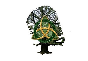
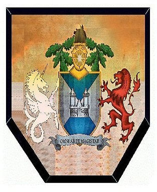
Flag: A' Choille Gaisgeach (Forest Warrior) - A field of white for purity and faith. An image of a Grandmother Oak: representing the magick of life. The Celtic Triquetra Knot superimposed upon the tree represents the unity between all nations as one.
Anthem: "The Old Ways" by Loreena McKennitt
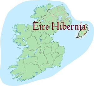
Provinces: Alba Caledonia (Scotland), Éire Hibernia(Ireland and Isle of Man), Galicia (Galicia, Asturias, and Cantabria {Spain}; and Minho {Portugal})
Royal District: Earra-Ghaìdheal agus Bòd (Argyll and Butte, Scotland)
Royal Court: Caer Ceann Loch Chille Chiarain (Campbeltown, Argyll and Bute, Scotland)
Royal Home: The Hearthstane
Celtican Provinces
Name of Royal District: Earra-Ghaìdheal agus Bòd
Location: Argyll and Bute, Scotland
Population(current): 2
Origin of name: Gaelic Spelling for Argyll and Bute, Scotland. Roughly translated, "Coast of the victorious Gaels".
Ruler(s): Magistar Mormaer


Name of province: Alba Caledonia
(Click on flag or name to navigate)
Location: Scotland (minus Argyll and Bute)
Population(current): 0
Origin of name: Two of the ancient names of Scotland. Alba is Indo-European for "white", while Caledonia is Proto-Celtic for "hard-footed"
Ruler(s): None at current time
Duchies(to date): None at current time
Provincial Pennant: The Standard of Alba - The Cross of Saint Andrew (in Gaelic, Bratach na h-Alba). Legend says that in the ninth century, the Pictish king, Angus mac Fergus, adopted St Andrew as the patron saint after seeing a Saltire appear in the sky, immediately before his victory at Athelstaneford.
The field of yellow, with Unicorn Rampant as an incorporation of The Royal Standard of Scotland and Scotland's National Animal, a symbol of purity, innocence and power in Celtic mythology and the supporting beast of the Arms of Scotland.
Name of province: Éire Hibernia
Location: Northern Ireland, Republic of Ireland (minus Counties Dublin, Meath, and Louth), and the Isle of Man
Population(current): 0
Origin of name: Two of the ancient names of Ireland. Éire from the name Ériu: the namesake, patron goddess, and divine genius loci of the island of Ireland. Hibernia is the Latin name for the Isle: thought to have originally meant "abundant land"
Ruler(s): None at current time
Duchies(to date): None at current time

Name of province: Galicia
Location: The Spanish areas of Galicia, Asturias, and Cantabria; and the Portugese area of Minho.
Population(current): 0
Origin of name: Named for the Spanish autonomous region of Galicia: the last of the seven Celtic Nations
Ruler(s): None at current time
Duchies(to date): None at current time
Places of Interest, Power, and Enchantment
Places of Interest, Power, and Enchantment

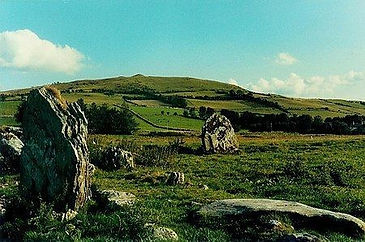
Schiehallion
Schiehallion
Each Realm has within it a unique place of power and sacredness. Some more unique than others.
Here, is the mount that weighs the planet. Here is a mount that holds hidden an entrance to the Celtic underworld. Here lies a mount in the heart of Scotland.
Where the Realm of the Dreamtime holds Uluru, and the Realm of LoneStar holds Enchanted Rock, the Realm of Celtica holds Schiehallion.
Schiehallion (Scottish Gaelic: Sìdh Chailleann) is a prominent mountain in Perth and Kinross, Scotland. Schiehallion has a rich botanical life, interesting archaeology, and a unique place in scientific history for an 18th-century experiment in "weighing the world".
The name Schiehallion is a Scoticised form of the Gaelic name Sìdh Chailleann, which translates as "Mound of the Caledonians", although Maskelyne (1772) reported a translation of "Constant Storm", besides a Lowland Scots name of "Maiden-Pap".
Schiehallion lies between Loch Tay, Loch Rannoch and Loch Tummel, about 10 miles (16 kilometres) to the west-north-west of Aberfeldy in Perthshire. The mountain, with an elevation of 3,553 ft, is isolated from other peaks and has an almost perfectly conical shape from the West. Schiehallion is sometimes described as the centre of Scotland, as it lies only 5 km west of the centre of gravity of mainland Scotland.
The majority of Schiehallion consists of quartzite, a rock formed from an original sand by heat and pressure. Quartzite is a white or pinkish rock, in which the dominant mineral is quartz. People often mistakenly think that Schiehallion is an extinct volcano because its shape is reminiscent of an active volcano. In fact, it was formed by sedimentary processes and the shape is the result of erosion by ice during the ice ages.
Schiehallion's isolated position and regular shape led it to be selected by Charles Mason for a ground-breaking experiment to estimate the mass of the Earth in 1774. The deflection of a pendulum by the mass of the mountain provided an estimate of the mean density of the Earth, from which its mass and a value for Newton's gravitational constant G could be deduced.
(from Wikipedia)
According to lore, the Uamh Tom a’ Mhor-fir - the Cave of the Great Man - lies somewhere at the Southwestern feet of the mountain: the home of Fae and other supernatural beings, a meeting place between local tribes and Queen Mab, and the dwellingplace of the Great Man himself. In addition to these things, the mountain is said to be sacred to the Divine Hag, the Cailleach: whose mark and influence stretches across the Isles - from her throne of Ben Nevis, to her likeness at Hag's Head at the Cliffs of Moher in Ireland.
The Slieve na Cailleach
The Slieve na Cailleach
The Cailleach - the Divine Giantess and Hag - left her touch and influence on her stride across Scotland and Ireland to the Cliffs of Moher. Halfway to her destination: perhaps by happenstance or not, she created the Slieve na Cailleach.
Slieve na Calliagh (Irish: Sliabh na Caillí or Sliabh na Cailleach, meaning 'the Cailleach's mountain') are a range of hills and ancient burial site near Oldcastle, County Meath, Ireland. The summit is 906 ft: the highest point in the county. On the hilltops are about twenty passage tombs, some decorated with rare megalithic art, which were built in the 4th millennium BC. Also called the Loughcrew tombs, it is one of the main passage tomb cemeteries in Ireland, along with Brú na Bóinne, Carrowkeel and Carrowmore.
The hills are named after the Cailleach, the divine hag of Irish mythology. Legend has it that the monuments were created when a giant hag, striding across the land, dropped her cargo of large stones from her apron.
The cairns are passage graves which date from around 3,000 BC and research on human remains found in association with similar monuments elsewhere in Ireland suggests that the builders were the descendants of people who settled in Ireland from modern Brittany around 4,200 BC.[3] The two main cairns on the site are tumuli known as Cairn L and Cairn T, Cairn T is also called Tomb of the Ollamh Fodhla or the Hag's Cairn, and so far more than 30 existing archaeological sites have been identified and there may once have been between fifty and one hundred mounds in the area. Within Cairn T is a carved stone, called the Equinox Stone, which is illuminated by the sun at the dawn of the Spring equinox, above this stone is a decorated ceiling stone which is also illuminated by the sun during the sunrise at the Spring equinox.
(from Wikipedia)
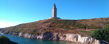
The Tower of Hercules
The Tower of Hercules
The Tower of Hercules (Spanish: Torre de Hércules) is the oldest extant lighthouse known. It has an ancient Roman origin on a peninsula about 2.4 km (1.5 mi) from the centre of A Coruña, Galicia, in north-western Spain. Until the 20th century, it was known as the Farum Brigantium.[2] The Latin word farum is derived from the Greek Φάρος, Pharos, for the Lighthouse of Alexandria. The structure stands 55 metres (180 ft) tall and overlooks the North Atlantic coast of Spain
The tower is known to have existed by the 1st century, built or perhaps rebuilt under Trajan, possibly on foundations following a design that was Phoenician in origin. Built with the original plans of the Lighthouse of Alexandria. Its base preserves a cornerstone with the inscription MARTI AUG.SACR C.SEVIVS LVPVS ARCHTECTVS AEMINIENSIS LVSITANVS.EX.VO, permitting the original lighthouse tower to be ascribed to the architect Gaius Sevius Lupus, from Aeminium (present-day Coimbra, Portugal) in the former province of Lusitania, as an offering dedicated to the Roman god of war, Mars. The tower has been in constant use since the 2nd century and is considered to be the oldest existent lighthouse. The original tower was shorter and wider, as the surviving core was surrounded by a spiral ramp. The outline of this ramp is still visible in the restored exterior. The final storey was likely surmounted with a dome.
In 1788, the surviving 112-ft tower core was given a neoclassical restoration, including a new 69-ft fourth story. The restoration was undertaken by naval engineer Eustaquio Giannini during the reign of Charles III of Spain, and was finished in 1791. UNESCO praised the work: "The Tower of Hercules was restored in the 18th century in an exemplary manner, which has protected the central core of the original Roman monument while restoring its technical functions". Within, the much-repaired Roman and medieval masonry may be inspected.
Through the millennia many mythical stories of the lighthouse's origin have been told. According to a myth that mixes Celtic and Greco-Roman elements, the hero Hercules slew the giant tyrant Geryon after three days and three nights of continuous battle. Hercules thenin a - Celtic gesture - buried the head of Geryon with his weapons and ordered that a city be built on the site. The lighthouse atop a skull and crossbones representing the buried head of Hercules’ slain enemy appears in the coat-of-arms of the city of A Coruña.
Another legend embodied in the 11th-century Irish compilation Lebor Gabála Érenn—the "Book of Invasions"—King Breogán, the founding father of the Galician Celtic nation, constructed a massive tower of such a grand height that his sons could see a distant green shore from its top. The glimpse of that distant green land lured them to sail north to Ireland. According to the legend, Breogán's descendants stayed in Ireland and are the Celtic ancestors of the current Irish people. A colossal statue of Breogán has been erected near the Tower.
(from Wikipedia)
Celtica
is ruled under an
Ogham Fews
administration
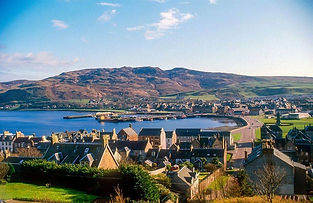
A view of downtown
Caer Ceann Loch Chille Chiarain,
Royal Court of the Realm of Celtica
Contact Magistar Mormaer: